San Luis Obispo, California
| City of San Luis Obispo | |||
|---|---|---|---|
| — City — | |||
 |
|||
|
|||
| Nickname(s): SLO | |||
 |
|||
| Coordinates: | |||
| Country | United States | ||
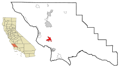
| State | California | ||
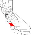
| County | San Luis Obispo | ||
| Incorporated | February 16, 1856 | ||
| Government | |||
| - Mayor | Dave Romero | ||
| - State Senate | Abel Maldonado (R) | ||
| - State Assembly | |||
| Area | |||
| - Total | 10.8 sq mi (27.7 km2) | ||
| - Land | 10.7 sq mi (27.6 km2) | ||
| - Water | 0.2 sq mi (0.5 km2) | ||
| Elevation | 233 ft (71 m) | ||
| Population (2000 census) | |||
| - Total | 44,174 | ||
| - Density | 4,144.5/sq mi (1,600/km2) | ||
| Time zone | PST (UTC-8) | ||
| - Summer (DST) | PDT (UTC-7) | ||
| ZIP codes | 93401-93403, 93405-93410, 93412 | ||
| Area code(s) | 805 | ||
| FIPS code | 06-68154 | ||
| GNIS feature ID | 1652788 | ||
| Website | http://www.slocity.org/ | ||


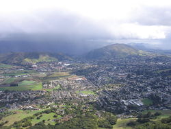
San Luis Obispo (pronounced /ˌsæn ˈluːɪs oʊˈbɪspoʊ / (![]() listen); Spanish for St. Louis, the Bishop) is a city in California, located midway between San Francisco and Los Angeles on the Central Coast. Founded in 1772, San Luis Obispo is one of California’s oldest communities. The city, referred to locally as "SLO", "SLOtown", "S.L.O" and "San Luis", is the county seat of San Luis Obispo County and is adjacent to California Polytechnic State University (Cal Poly). As of the 2006 Census Bureau estimate,[1] the city population was 42,963 (down 2.8% from 2000).
listen); Spanish for St. Louis, the Bishop) is a city in California, located midway between San Francisco and Los Angeles on the Central Coast. Founded in 1772, San Luis Obispo is one of California’s oldest communities. The city, referred to locally as "SLO", "SLOtown", "S.L.O" and "San Luis", is the county seat of San Luis Obispo County and is adjacent to California Polytechnic State University (Cal Poly). As of the 2006 Census Bureau estimate,[1] the city population was 42,963 (down 2.8% from 2000).
Contents |
History
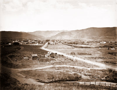
Earliest human inhabitants of the local area were the Chumash peoples, who settled in the vicinity circa 5,000 to 10,000 years BC. One of the earliest villages lies south of San Luis Obispo, and reflects the landscape of the early Holocene when estuaries came farther inland and sea levels were higher. These Chumash people exploited marine resources of the inlets and bays along the Central Coast and inhabited a network of villages including sites at Los Osos and Morro Creek.[2]
San Luis Obispo once had a burgeoning Chinatown in the vicinity of Palm St. and Chorro St. Laborers were brought from China by Ah Louis in order to construct the Pacific Coast Railway, roads connecting San Luis Obispo to Paso Robles and Paso Robles to Cambria, and also the 1884 to 1894 tunneling through Cuesta Ridge for the Southern Pacific Railroad. SLO's Chinatown revolved around Ah Louis Store and other Palm Street businesses owned and run by Chinese business people. Today, Mee Heng Low chop suey shop is all that remains of the culture, although a revitalized Chinatown development is being planned. A display of some of the unearthed relics from this period can be seen on the first floor of the Palm Street parking garage, which was built over the location where Chinatown once stood. The San Luis Obispo Historical Society (adjacent to the Mission) also contains rotating historical exhibits.[3]
San Luis Obispo was also a popular stop on both U.S. Route 101 and California State Route 1 with the rise of car culture. Due to its popularity as a stop, it was the location of the first motel, the Milestone Mo-Tel.
Among San Luis Obispo's historical buildings is the former San Luis Obispo Carnegie Library, located at 696 Monterey Street. The San Luis Obispo Carnegie Library was built in 1905 with a grant of $10,000 from Andrew Carnegie, who funded the establishment of 142 California libraries in the early 1900s. The Romanesque style building was designed by architect W.H.Weeks of Watsonville, California and was built by contractor Joseph Maino of San Luis Obispo. As one of numerous California public buildings designed by W. H. Weeks, it shares features with Carnegie libraries in nearby Lompoc and Paso Robles.[4] The San Luis Obispo Carnegie building served as the city library until 1955, when a new public library was built at the corner of Palm and Morro Streets.[5] It has been home to the San Luis Obispo County Historical Museum since 1956.[6] The Carnegie Library building is listed on the National Register of Historic Places.[7]
San Luis Obispo's largest and oldest voluntary organization is the San Luis Obispo Chamber of Commerce, which also is the oldest and largest voluntary organization in San Luis Obispo County. As an independent non-profit corporation (not affiliated with government or any other agency), the San Luis Obispo Chamber of Commerce uniquely serves the needs of its 1,400 members. For more than 105 years, it has been dedicated to enhancing the economic health of the San Luis Obispo area and the prosperity of its members.
Geography
San Luis Obispo is located at 35°16'27" North, 120°39'47" West (35.274305, -120.663192)[8].
According to the United States Census Bureau, the city has a total area of 10.8 square miles (28 km2), of which, 10.6 square miles (27 km2) of it is land and 0.18 square miles (0.47 km2) of it (1.66%) is water.
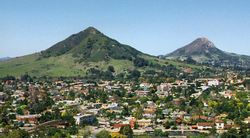
San Luis Obispo is on the West Coast of the United States and in the Central Coast of California. The Pacific Ocean is only about 11 miles (18 km) west of San Luis Obispo. The Santa Lucia Mountains lie just east of San Luis Obispo.
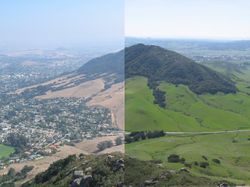
San Luis Obispo is a seismically active area; there are a number of nearby faults including the San Andreas Fault. The Nine Sisters are a string of hills that partially run through San Luis Obispo. They are geologically noteworthy for being volcanic plugs. Six of the nine peaks are open to the public for recreation.[9]

Climate
San Luis Obispo experiences a cool Mediterranean climate (Köppen climate classification Csb). On average it has 50 days with measurable rain per year - mostly during winter months. Summers are generally warm and sunny, often with morning fog from the Pacific coast. Winters are generally mild, though below freezing lows may be expected 4 nights per year. Temperatures do, however, vary widely at any time of the year, with 80 °F readings in January and February not uncommon. Storms of any kind are rare (although in October 2009 an unusually-powerful early-season storm drenched the city with nearly 8 inches of rain).
| Climate data for San Luis Obispo | |||||||||||||
|---|---|---|---|---|---|---|---|---|---|---|---|---|---|
| Month | Jan | Feb | Mar | Apr | May | Jun | Jul | Aug | Sep | Oct | Nov | Dec | Year |
| Average high °F (°C) | 64.6 (18.11) |
65.9 (18.83) |
66.8 (19.33) |
70.8 (21.56) |
73.2 (22.89) |
77.6 (25.33) |
80.3 (26.83) |
81.7 (27.61) |
81.8 (27.67) |
78.7 (25.94) |
72.0 (22.22) |
66.4 (19.11) |
73.3 (22.94) |
| Average low °F (°C) | 41.9 (5.5) |
43.6 (6.44) |
44.5 (6.94) |
45.4 (7.44) |
47.5 (8.61) |
50.6 (10.33) |
52.7 (11.5) |
53.3 (11.83) |
52.8 (11.56) |
49.8 (9.89) |
45.5 (7.5) |
41.6 (5.33) |
47.4 (8.56) |
| Rainfall inches (mm) | 5.28 (134.1) |
5.41 (137.4) |
4.48 (113.8) |
1.31 (33.3) |
0.47 (11.9) |
0.09 (2.3) |
0.03 (0.8) |
0.08 (2) |
0.44 (11.2) |
0.99 (25.1) |
2.17 (55.1) |
3.61 (91.7) |
24.36 (618.7) |
| Avg. rainy days | 9.0 | 8.5 | 9.1 | 4.5 | 2.3 | 0.6 | 0.5 | 0.4 | 1.4 | 2.8 | 5.2 | 5.9 | 50.2 |
| Source: [10] | |||||||||||||
Demographics
As of the 2009 census[11], there are 44,750 people, 18,639 households, and 7,697 families residing in the city. The population density is 4,144.5 people per square mile (1,600.0/km²). There are 19,306 housing units at an average density of 1,811.3/sq mi (699.3/km²). The racial makeup of the city is 84.11% White, 1.46% African American, 0.65% Native American, 5.28% Asian, 0.13% Pacific Islander, 4.82% from other races, and 3.55% from two or more races. 11.65% of the population are Hispanic or Latino of any race.
There are 18,639 households out of which 17.7% have children under the age of 18 living with them. 31.3% are married couples living together, 7.2% have a female householder with no husband present, and 58.7% are non-families. 32.7% of all households are made up of individuals and 9.5% have someone living alone who is 65 years of age or older. The average household size is 2.27 and the average family size is 2.86.
In the city the population is spread out with 14.2% under the age of 18, 33.6% from 18 to 24, 23.7% from 25 to 44, 16.5% from 45 to 64, and 12.1% who are 65 years of age or older. The median age is 26 years. For every 100 females there are 105.8 males. For every 100 females age 18 and over, there are 106.3 males.
The median income for a household in the city is $31,926, and the median income for a family is $56,319. The median household income in San Luis Obispo County is $60,534, and the median family income is $72,327. Males have a median income of $41,915 versus $27,407 for females. The per capita income for the city is $20,386. 26.6% of the population and 7.1% of families are below the poverty line. Out of the total population, 9.3% of those under the age of 18 and 4.6% of those 65 and older are living below the poverty line.
Government
Local
San Luis Obispo is an incorporated city, and it is also the county seat of San Luis Obispo County. The city is governed by a mayor who is elected to two year terms and four city council members who are elected to four year terms.[12] The fire department of San Luis Obispo was first organized in 1872 and now has forty-five full-time firefighters and four fire stations (as of 2007[update]).[13]
Fire Department
The SLO City Fire Stations are staffed with three man ALS engine companies and a four man ALS Truck company. Each apparatus has at least one Paramedic on duty each day. The department responds to over 4,500 calls each year. The San Luis Obispo City Fire Department also maintains a bike medic program which is used at Farmer's market and other special events throughout the City. Four members of the Fire Department are also on the San Luis Obispo SWAT Team as SWAT Medics and respond using Squad 1 (an ALS equipped ambulance which also carries some light rescue gear and other specialty tools) The front-line members of the department are represented by the San Luis Obispo City Firefighters' IAFF Local 3523.[13]
Notable Ordinances
In June 1990 City Councilman Jerry Reiss proposed a city ordinance to ban smoking in all indoor public areas. Following a failed effort by R.J. Reynolds Tobacco Co. to defeat the ordinance, the City Council voted 4-1 in favor on June 19, 1990 with only Mayor Ron Dunin dissenting. As a result, on August 2, 1990, San Luis Obispo became the first municipality in the world to ban smoking in all public buildings, including bars and restaurants. This statute has been a catalyst worldwide in anti-smoking legislation.[14][15][16] In April, 2010, San Luis Obispo strengthened its anti-smoking legislation, making smoking in public, excepting for certain conditions, a citable offense beginning on June 20, 2010[17].
In 1982, following public hearings, the City Council approved an ordinance forbidding the construction of "drive-through" businesses.[18] In-N-Out Burger opened a restaurant in the nearby town of Atascadero because of the ban.[19] In 2008 the City Council voted 3-2 to keep the ban.[20][21] The first fast food chain restaurant in SLO, a McDonald's, has closed.[22][23]
In 1982 a city ordinance was passed that prohibited the sale of alcoholic beverages at any business selling gasoline, with the exception of one Mobil (now Union 76) service station on South Higuera Street that was grandfathered in prior to the ordinance. The city council voted 3-2 to abolish the ordinance in 2004.[24]
In April 2010, an Unruly Gathering ordinance passed that specifically targets young college students and fines them $750 for the first offense if a gathering has over 20 people and is considered to be disturbing the peace.[25]
State and Federal
In the state legislature San Luis Obispo is located in the 15th Senate District, represented by Republican Abel Maldonado, and in the 33rd Assembly District, represented by Republican Sam Blakeslee. Federally, San Luis Obispo is located in California's 23rd congressional district, which has a Cook PVI of D +9[26] and is represented by Democrat Lois Capps.
Economy
San Luis Obispo County’s economy is truly a post-industrial economy (slochamber.org). It could be better categorized as a service economy.
What the government classifies as “service jobs” account for 38% of the county’s jobs, the true service sector is larger. Government jobs accounts for 20.7% of the County, which is also recognized as a service sector. The presence of Finance, Insurance, and Real Estate sector can also be classified as a service sector. Services and Retail combined accounts for 75% of county jobs. Manufacturing jobs now represent less than 6% of the county jobs.
Downtown San Luis Obispo is centered around the carefully restored Mission San Luis Obispo de Tolosa. The downtown area also has many eclectic shops and boutiques. New downtown shopping centers have been added in recent years. The Court Street Center and Downtown Center house stores that belong to nationwide chains.
One of the primary draws of this area for students, visitors, and residents alike is the plethora of outdoor sports such as hiking, kayaking, surfing, windsurfing, diving, sailing, and kite boarding.
Scenes from the 1990 film My Blue Heaven were filmed in commercial areas of San Luis Obispo.
Southwest of the town center, several large shopping centers have developed since 2003.
Education

All public K-12 institutions in San Luis Obispo are operated by San Luis Coastal Unified School District, which contains seven elementary schools, one junior high school, and one high school, San Luis Obispo High School. There are also two private elementary schools and one private high school, Mission College Prep.
San Luis Obispo is also home to California Polytechnic State University (Cal Poly), a public university enrolling nearly 20,000 students. The community is also served by Cuesta College, a community college a short driving distance away.
Transportation
The city is home to San Luis Obispo County Regional Airport which offers private and commercial air service to several major cities. Amtrak provides daily rail transport service here as the northern terminus of the Pacific Surfliner line from San Diego, and as a stop on the Coast Starlight line. The Amtrak train goes north to San Francisco, Portland, and Seattle, and south to Los Angeles. Greyhound closed its doors in San Luis Obispo on March 12, 2009. It still continues to service San Luis Obispo and currently uses a transit bus stop on Railroad Avenue. Public transit includes the city-wide SLO Transit bus lines as well as the county-wide SLO Regional Transit system. Rideshare encourages the use of the local public transit, as well as carpooling and cycling. Riders for the SLO Transit system are now able to plan their trips using Google Transit. [4] The SLO Car Free program provides an online one-stop-shop for all car-free vacationing needs from bus schedules and bike maps, to discounts on transportation, lodging, and attractions. [5]
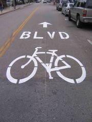
Bicycling is increasing as a mode of transportation. The Bill Roalman (Morro Street) Bicycle Boulevard gives priority to bicycle traffic while a special bicycle traffic signal (one of only a handful in the United States) allows bicyclists their own phase in traffic flow. The SLO County Bicycle Coalition offers a free bicycle valet service during the weekly Farmers' Market. In 2007, the city was designated as a Bicycle Friendly Community at the Silver level by the League of American Bicyclists.
The city provides parking in three multistory parking structures downtown [6]. Street parking downtown is metered. The city's innovative Racks with Plaques program has increased bike racks in the downtown area and has cut down on parking congestion.
Culture
The Madonna Inn is a famous local landmark. Established by Alex Madonna in 1958, the inn is famously eccentric. The Fremont Theater, a historic Art Deco theater from the 1940s, still plays first run movies on the huge screen. Murals adorn the walls of the main theater while neon swirls light the ceiling. The Palm Theatre boasts solar heating and is home to the San Luis Obispo International Film Festival. Another destination is Bubblegum Alley. Since about 1960, people have been sticking chewed gum on the walls of this alley. The doctor's office on the corner of Santa Rosa and Pacific streets is one of very few commercial buildings designed by Frank Lloyd Wright. San Luis also has a Carnegie Library which is now home to the San Luis Obispo County Historical Museum.[27]
One of the largest Mardi Gras parades West of the Mississippi used to be held in San Luis Obispo, but it has been canceled recently because of difficulties related to crowd control and alcohol consumption.
Cal Poly's open house, Poly Royal, was held annually from 1933 to 1990. It was canceled in 1945 due to war rationing.[28] It began as a show-and-tell for students to display their projects. It traces its origins to the 1904 Farmer's Institute and Picnic Basket. By the 1980s, as the college became "the most popular...university in the 19-campus CSU system," Poly Royal began drawing over 100,000 people from throughout the state, including 126,000 people in 1985. Concerts, parties, and other entertainment were added and it earned $3–4 million in revenue for the city every year.[29][30]
Following a "mini-riot" in 1989 at an off-campus apartment during Poly Royal, the events in 1990 would cancel the event "indefinitely." Two nights of rioting on April 28–29 led to 127 arrests, over 100 injuries and 14 police injuries on top of "several hundred thousand dollars" worth of damage. A liquor store near campus, Campus Bottle, was destroyed by revelers demanding alcohol. The second night was much larger than the first as people were leaving a concert on campus and parties off-campus were broken up and revelers flooded the streets. Mayor Dunin called the events "the worst experience in the history of San Luis Obispo.” After a meeting between Mayor Dunin and University President Warren Baker the following Monday, Poly Royal was canceled from that point forward. The name Poly Royal returned in 2001 as "Open House Presents Poly Royal," a scaled down version that was designed for students and parents.[31][32][33][34][35]
San Luis Obispo has been home of several other events, including a stop on the way of the Olympic Flame Relay, the Tour of California bicycle race, Cinco de Mayo celebrations, an annual Mozart festival, held every July, and a long-standing Christmas Parade. Another attraction is the development of Edna Valley into a well-known wine region. Just south of the city, people can spend an afternoon wine tasting several wineries in the area with a very short drive. The wine region extends north beyond Paso Robles (30 miles north) and south to Santa Ynez (70 miles south).
During Summer months, local residents and visitors congregate in the Mission Plaza for a free outdoor concert every Friday evening. The event is called Concerts in the Plaza. Other noteworthy events include the San Luis Obispo International Film Festival, Festival Mosaic, and the Plein Air Festival.[36]
San Luis Obispo hosts a Farmer's Market every Thursday night at 6PM on Higuera Street, between Osos and Nipomo Streets. During this weekly event, the street is closed to vehicle traffic while vendors sell food and goods and various visual and music artists perform for the crowds.
Since June 2000, the first Thursday of every month is The Bike Happening (also known as Bike Nite) in San Luis Obispo. People gather after the Farmer's Market at the Mission Plaza with their bikes. The bikers then go around on multiple circuits on the main streets of downtown adhering to the traffic laws (for the most part). The ride is considered a fun/social ride meant to encourage people to get back on their bikes and to have fun. Each Bike Happening has a theme and a large portion of the crowd is in some costume adherent to the theme.[37]
One of the cultural focal centers of San Luis Obispo is the Christopher Cohen Performing Arts Center built on the Cal Poly Campus, which was constructed utilizing the donations of local businesses and individuals. The Performing Arts Center consists of multiple venues, including the original Spanos Theatre. The largest venue, Harmon Hall, seats 1,300. Many high school and college programs are scheduled. Local artists perform plays, music and dance. The addition of the Performing Arts Center attracts many touring performances which are usually not found in communities of comparable size to San Luis Obispo. The Summer of 2007 was the opening concert of the Forbes Pipe Organ, which was built elevated into a side wall of Harmon Hall and required the donation of a further $3 million for purchase and installation.[38]
Notable residents
Born or Raised in San Luis Obispo
- Stephanie Brown Trafton, Olympic athlete
- Zac Efron, actor
- Jim Lonborg, baseball player
- Arron Oberholser, golfer
- Chris Pontius, daredevil entertainer (Jackass)
- Paul Rachubka, soccer player
- Loren Roberts, golfer
- Chris Seitz, soccer player
- Jenaveve Jolie, porn actress
- Jeremy Nolen, Chef
Lived in San Luis Obispo
- Jon Anderson, musician (Yes)
- Ernie Ball, guitarist and entrepreneur
- John Barbata, musician
- Peter Buck, musician (R.E.M.)
- John Darnielle, musician (The Mountain Goats)
- Allen Fox, tennis player and coach
- Jack Kerouac, writer[39]
- Mike Krukow, baseball player and sportscaster
- Chuck Liddell, champion mixed martial artist
- Ah Louis, Chinese American pioneer and businessman
- Hannah Marks, actress[40]
- Lee Michaels, musician
- Rich Ferguson, magician
- G.D. Spradlin, actor
- The Pendragons, magicians
Attended California Polytechnic State University
Notable bands
- All Kinds Of Crazy, a Rock n' Roll band
- Grand Lake, an Indie rock band
- KauzaFex, Indie Hip-Hop band
- Lakes, Indie Rock band
- The Sentinals, 1960s surf band
- Sherwood, an Indie rock band
- Watashi Wa, pop rock band
- Still Time, an Indie rock band
- Scissors For Lefty, an Indie rock band
- Chase McBride, a folk revival band
Notes and references
- ↑ 2006 Census Bureau estimate
- ↑ C.Michael Hogan (2008) Morro Creek, The Megalithic Portal, ed. by A. Burnham [1]
- ↑ Five Views: An Ethnic History Site Survey
- ↑ http://www.hmdb.org/marker.asp?marker=11605
- ↑ http://www.slochs.org/museum.asp
- ↑ http://www.slochs.org/building.asp
- ↑ http://www.nationalregisterofhistoricplaces.com/CA/San+Luis+Obispo/state.html
- ↑ "US Gazetteer files: 2000 and 1990". United States Census Bureau. 2005-05-03. http://www.census.gov/geo/www/gazetteer/gazette.html. Retrieved 2008-01-31.
- ↑ "The Nine Sisters of San Luis Obispo County". Sierra Club. http://santalucia.sierraclub.org/ninesis.html. Retrieved 2007-02-12.
- ↑ "San Luis Obispo historic weather averages". Intellicast. http://www.intellicast.com/local/history.aspx?location=USCA1000.
- ↑ "American FactFinder". United States Census Bureau. http://factfinder.census.gov. Retrieved 2008-01-31.
- ↑ "City Government: City Structure". City of San Luis Obispo. http://www.slocity.org/organization.asp. Retrieved 2007-02-12.
- ↑ 13.0 13.1 "City of San Luis Obispo Fire Department". City of San Luis Obispo. http://www.ci.san-luis-obispo.ca.us/fire/about.asp. Retrieved 2007-05-22.
- ↑ "Letter to Nebraska Senators from San Luis Obispo Chamber of Commerce in favor of Smokefree Legislation". Tobacco.org. http://www.tobacco.org/News/010129garth.html. Retrieved 2007-04-07.
- ↑ http://articles.latimes.com/1990-08-02/news/mn-1350_1_san-luis-obispo
- ↑ STRICT SMOKING BAN OK'D, San Jose Mercury News, June 21, 1990
- ↑ San Luis Obispo Smoking Ban Now in Effect
- ↑ http://www.sanluisobispo.com/178/story/73096.html
- ↑ http://www.atascadero.org/media/council/2c72cfcC-1-Drive-thrus.pdf
- ↑ http://www.qsrmagazine.com/articles/features/120/emissions-1.phtml
- ↑ http://www.qsrweb.com/article.php?id=9886
- ↑ http://www.slochamber.org/cm/E-Insider/December102008.html
- ↑ "San Luis Obispo Municipal Code Chapter 17.22 - Use Regulations". http://www.codepublishing.com/CA/SanLuisObispo/sanluisobispo17/SanLuisObispo1722.html#17.22.010. Retrieved 2009-08-18.
- ↑ Lynem, Julie (2004-02-18). "San Luis Obispo, Calif., City Council Allows Gas Stations to Sell Beer, Wine". The Tribune (San Luis Obispo). AllBusiness.com. http://www.allbusiness.com/government/government-bodies-offices-regional/10274368-1.html. Retrieved 2008-12-22.
- ↑ Barba, Jessica. "Unruly gathering ordinance passes without protest". Mustang Daily. http://mustangdaily.net/unruly-gathering-ordinance-passes-without-protest/.
- ↑ "Will Gerrymandered Districts Stem the Wave of Voter Unrest?". Campaign Legal Center Blog. http://www.clcblog.org/blog_item-85.html. Retrieved 2008-02-10.
- ↑ [2]
- ↑ http://lib.calpoly.edu/universityarchives/history/polyroyal/print.html
- ↑ http://articles.latimes.com/1985-05-28/news/mn-16267_1_cal-poly-pomona
- ↑ http://www.centennial.calpoly.edu/poly_royal.html
- ↑ http://articles.latimes.com/1990-04-29/news/mn-498_1_cal-poly
- ↑ http://articles.latimes.com/1990-04-30/news/mn-112_1_cal-poly-student
- ↑ http://articles.latimes.com/1990-05-01/news/mn-145_1_cal-poly
- ↑ http://articles.latimes.com/1990-04-30/news/mn-277_1_cal-poly
- ↑ http://sloblogs.thetribunenews.com/slovault/2009/04/30/poly-royal-riot-1990/
- ↑ [3]
- ↑ [BikeHappening.org]
- ↑ [pacslo.org]
- ↑ http://www.newtimesslo.com/cover/2443/off-the-road/
- ↑ Hollywood Elementary, New York Times Magazine, June 4, 2006
External links
- Economic Vitality Corporation of San Luis Obispo County
- The San Luis Obispo City-County Public Library
- The Tribune, the largest daily newspaper serving all of San Luis Obispo County
- San Luis Obispo New Times, alternative weekly newspaper with 100,000 circulation founded in 1986
- City of San Luis Obispo
- Downtown SLO Association has information about concerts in the plaza and Farmers' Market.
- San Luis Obispo Chamber of Commerce promotes member business and serves as the city's contracted tourism promoter. Also runs the city's Visitors Center, 1039 Chorro St.
- San Luis Obispo County Historical Society
- San Luis Obispo local weather
|
|||||||||||||||||
|
|||||||||||
|
|||||||||||||||||||||||